Parcel-Based Land Data: The Key to Accurate Flood Zone Determinations
When it comes to understanding a property’s flood risk, precision is everything. Many lenders, insurers, and investors rely on flood zone determinations to make critical financial and safety decisions, an to remain complaint. Yet, not all methods for locating a structure on a map are created equal. Traditional geocoding — translating a street address into a point on a map — is widely used, but it comes with inherent limitations that can affect accuracy. That’s why the utilization of parcel-based land data is key to producing reliable determinations.
Parcel-Based Land Data VS. Geocoding
Parcel-based land data refers to property-level geographic information derived from official records such as county assessor datasets, cadastral surveys, and property tax records. Unlike geocoding, which often places a structure at an approximate point based on an address, parcel data relies on actual surveyed boundaries and building footprints. This means that every structure is mapped exactly where it sits on the land, not just where a postal service delivers mail.
Parcel-based land data uses the property’s recorded land boundaries (from tax assessor or cadastral sources) to pinpoint exactly where a structure lies in relation to flood zones, elevation, and other mapped features.
Geocoding, on the other hand, simply converts a street address into a latitude and longitude — which can often land in the center of a parcel, along a driveway, or even at the wrong structure on multi-building lots.
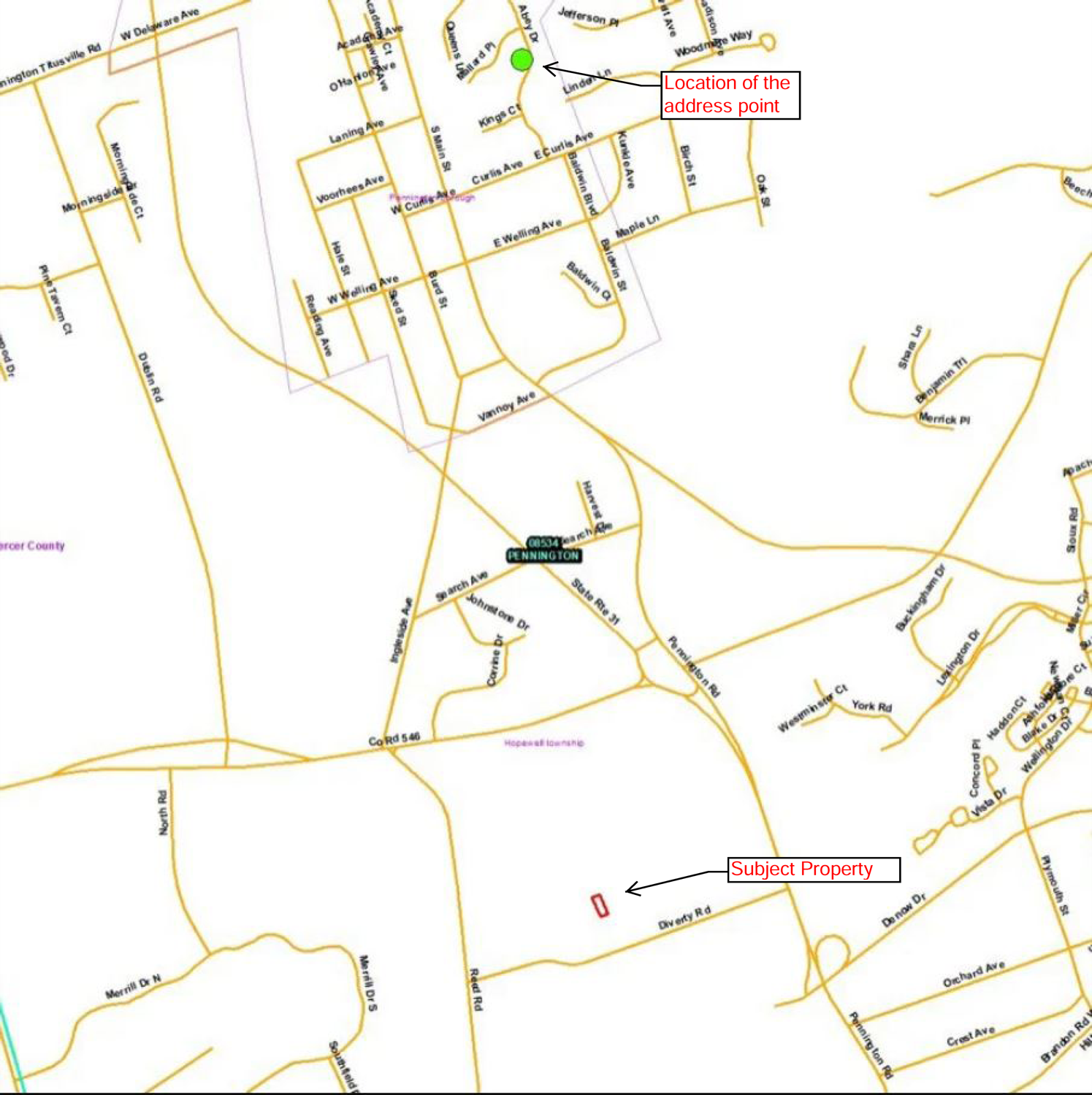
Take a look at the example below - The property with the red outline is correctly identified using parcel-based data, and the green dot is a location identified using a geocoded address point. These properties are 8,000 feet apart which is a major discrepancy.
5 Key Advantages of Parcel-Based Data
Using parcel-based land data ensures that flood zone determinations are grounded in the most accurate spatial information available. Here’s why it matters:
Pinpoint Precision
Parcel data aligns with surveyed property boundaries and building footprints, ensuring that the exact location of a structure is considered when determining flood risk.Structure-Specific Analysis
Unlike geocoding, parcel data allows analysts to account for each building separately, which is particularly important on large or multi-structure properties.Authoritative Source
Parcel data comes from official government records, which are already used for legal, taxation, and insurance purposes. This makes the information verifiable and defensible.Accurate Flood Zone Correlation
FEMA flood maps and other regulatory datasets are spatially precise. By aligning structures with parcel boundaries, parcel-based analysis ensures that flood zone determinations accurately reflect regulatory boundaries.Reliability Across All Property Types
Rural properties, multi-lot parcels, or irregularly shaped lots can pose challenges for geocoding. Parcel-based analysis removes guesswork, ensuring consistent accuracy regardless of location.

Our highly-detailed mapping and color-coded overlays make it clear and easy to identify property boundaries, structure locations and the exact locations of FEMA’s current flood zones.
The Limitations of Geocoding
Geocoding is convenient — you enter an address, and a latitude and longitude appears on a map. However, this convenience comes with trade-offs:
Inaccuracy on large or irregular parcels: A geocoded point may land near the center of the property or along a driveway rather than at the structure itself.
Multiple structures, one address: Some parcels have several buildings, and geocoding can’t distinguish which structure the flood determination applies to.
Rural and shared addresses: In less densely populated areas, geocoding can place a point hundreds of feet from the actual structure.
Potential compliance issues: Inaccurate placement may lead to misclassification of flood risk, which can create problems with insurance or regulatory reporting.
These issues highlight why relying solely on geocoding can result in errors or uncertainty in flood zone determinations.

Where Geocoded Property Data Commonly Appears
1. Flood zone determinations from generic data providers
Some lower-cost or automated services rely on geocoding to drop a pin near the center of a parcel—sometimes even in the street—rather than placing it accurately on the actual structure footprint.
2. Insurance quote platforms
Many instant-quote tools for homeowners insurance, NFIP policies, or private flood insurance use geocoded point placement to approximate a risk zone.
3. Real estate listing websites
Large listing platforms often geocode property addresses to place them on a map. This can lead to mislocated pins (e.g., across the street or on the wrong parcel).
4. Lending or underwriting tools that use automated location services
Some automated decision engines rely on third-party geocoding APIs (Google, Mapbox, etc.), which may not precisely match parcel boundaries—especially in rural or irregular areas.
5. Environmental risk screeners
Tools for hazards like wetlands, contamination, radon, or wildfire sometimes start with geocoded points to approximate the property’s location instead of analyzing the parcel geometry.
6. County or municipal map viewers (older systems)
Some legacy GIS portals still geocode addresses instead of using parcel centroids or footprints, which can cause mismatches.
7. Marketing or demographic lookup tools
Platforms that give quick stats about a neighborhood or property often rely on simple geocoding to determine location-based attributes.
The Implications for Flood Risk Management
Accurate flood zone determinations are more than just a technical detail — they are critical for financial, regulatory, and safety decisions. Incorrect assessments can result in:
Improper insurance requirements – Property owners may pay for unnecessary coverage or, conversely, lack adequate protection.
Regulatory compliance issues – Lending institutions and municipalities rely on accurate flood data for permitting and reporting.
Misguided mitigation efforts – Erroneous location data can misdirect flood mitigation measures, creating both safety and cost concerns.
With WTG’s parcel-based data-driven determinations, stakeholders can have confidence that every report reflects the true risk at the precise location of the structure. This precision supports better decision-making, reduces liability, and strengthens trust among lenders, insurers, and property owners.
Parcel-based land data provides accurate, defensible, and reliable results and this is why WTG goes beyond geocoding and employs parcel-based data in producing our industry-leading flood zone determinations. We want to ensure a foundation for confident decision-making for our clients. When choosing a partner for flood zone determinations, we are your experts and deliver accuracy you can trust.
The information provided is for informative purposes only and is not intended to be legal advice or a legal opinion. For legal advice, please consult an attorney.