How to Find Your Address on a FEMA Flood Map
If you’ve ever tried to determine whether a property is in a flood zone using FEMA’s online tools, you may have quickly realized just how confusing and time-consuming the process can be. Between the official Flood Insurance Rate Maps (FIRMs), technical language, and parcel boundaries that don’t always line up neatly, it’s easy to feel overwhelmed—especially when the stakes are high for homeowners, real estate professionals, or lenders.
That’s where Western Technologies Group (WTG) comes in. We take the guesswork out of flood zone determinations and offer a fast, accurate, and certified way to find out the flood zone status of any structure—anywhere in the United States.
Why Use a FEMA Flood Map?
FEMA’s Flood Insurance Rate Maps (FIRMs) are the official source for flood zone information used by banks, insurers, and municipalities. These maps are used to assess flood risk and determine whether flood insurance is required for a mortgage.
You can access FEMA’s maps through their Map Service Center. While this is a great resource, it isn’t always straightforward. You’ll need to locate your parcel, understand the map legend, and interpret various flood zones—such as AE, VE, X, and others—which can be difficult if you’re not familiar with the mapping system.
This process often leads to one big question: Am I looking at the right structure or lot? That’s where expert assistance becomes essential.

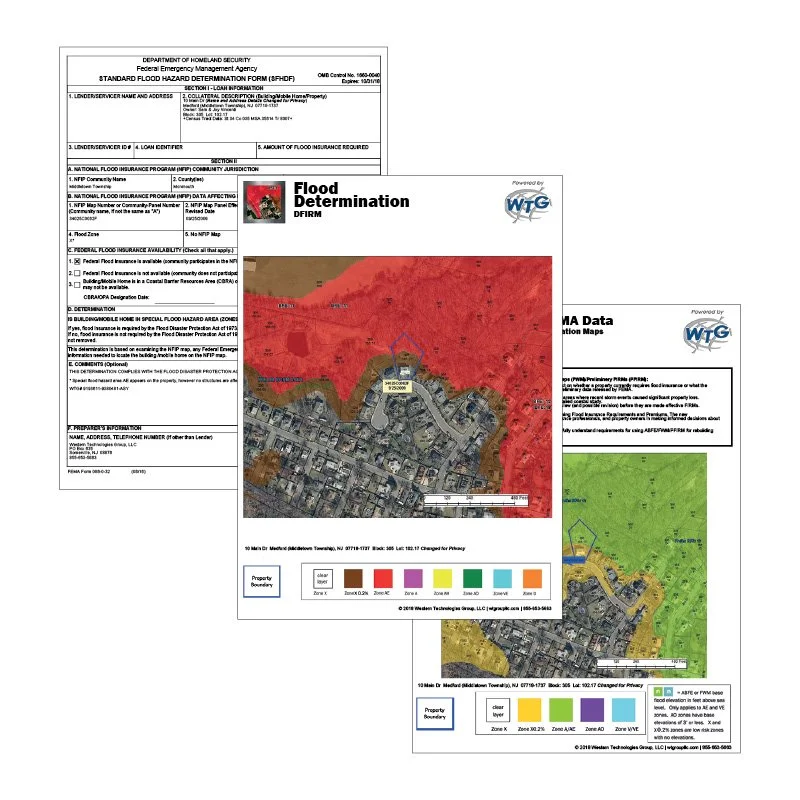
The WTG Difference: Certified, Confirmed, and Clearly Explained
At Western Technologies Group, we do more than just pull a map. When you order a Flood Zone Determination Certificate from WTG, you get:
Certified Results
Every flood certificate we issue is certified, meaning it's backed by our data and analysis and is suitable for use by lenders, insurers, real estate professionals, or homeowners. Whether you're buying a new property or reevaluating flood risk, our determinations hold weight.
Address Confirmation
One of the most common problems with FEMA flood map lookups is accidentally referencing the wrong parcel or structure—especially in rural areas, condominiums, or properties with multiple buildings.
That’s why we manually verify your address and property boundaries before we begin our analysis. Our trained experts ensure that the correct parcel and structure are being evaluated—so you don’t end up with flood zone information for the building next door.
Easy-to-Understand Map Overlays
FEMA maps can be intimidating, even for professionals. WTG transforms that complexity into clarity with visual overlays that clearly show your parcel in relation to the official FEMA flood zones.
Our overlays help you see exactly where your structure lies on the map, what zone it falls in, and how the flood risk is defined—all with color-coded and labeled visuals that make interpretation simple.
Expert Support
Flood zones can be confusing. If your property appears to be partially in a flood zone, or you receive conflicting information from different sources, we’re here to help.
Our team is available by phone or email to walk you through your flood certificate, explain the map details, and help you understand what it means for your insurance requirements or property plans. You’ll speak with real people with years of experience in floodplain management—not a chatbot or a generic help desk.

How to Order a Flood Certificate from WTG
Getting a flood zone determination with WTG is fast and easy—and there are two ways to get started, depending on who you are:
For Banking and Lending Professionals
If you're part of a lending institution or work in compliance, you can open a business account directly with WTG via westerntechnologiesgroup.com. This provides streamlined access to ordering, tracking, and managing flood determinations for all of your transactions, complete with billing options and dedicated support.
For Everyone Else
Homeowners, buyers, sellers, real estate agents, attorneys, insurance professionals—anyone can order a single, certified flood zone determination quickly and easily through our public-facing portal at MyFloodStatus.com.
Just enter your address, and we’ll take care of the rest—from confirming the location to generating a detailed, accurate report with FEMA overlays and expert insights.
What You'll Receive
When you order a flood certificate from WTG, you’ll receive:
A certified flood zone determination
High-quality map overlays showing the structure in relation to FEMA zones
FEMA Map Panel information and the effective date
Contact information for expert support
Delivery typically within one business day
Trusted Across Industries
Our flood certificates are relied on by:
Mortgage lenders and compliance officers
Insurance agents
Real estate agents and attorneys
Homebuyers and homeowners
No matter who you are or why you need flood zone information, WTG gives you the confidence of knowing your structure has been accurately evaluated by professionals.
Final Thoughts: Don’t Leave It to Chance
FEMA flood maps are valuable, but only if they’re interpreted correctly and applied to the right structure. A mistake in parcel placement or zone interpretation can lead to unnecessary insurance premiums—or worse, leave you unprotected.
With Western Technologies Group, you get more than a map—you get certainty. Backed by certified documentation, expert support, and clear visuals, our flood zone determinations are trusted across the country by professionals and property owners alike.
Ready to find out your flood zone status?
Professionals can get started at westerntechnologiesgroup.com
Everyone else can order online at MyFloodStatus.com
The information provided is for informative purposes only and is not intended to be legal advice or a legal opinion.